
Saturday, January 31, 2015
Limited snow for in the next while
The snow that I mentioned in my last post for Sunday night got pushed south by a stronger Arctic high (see below) though a couple models are still saying that we'll get a dusting from it on Monday. Looking ahead, the next opportunity will be the clipper on Wednesday. Otherwise, cold reigns.
Tuesday, January 27, 2015
Quick look ahead
While people in the maritimes get buried now in feet of snow, we'll get our few inches Thursday and next Sunday night. In between the snows will be cold. There is potential that if Sundays storm tracks a little farther north than its current track, then we will get more than a few inches.
Monday, January 26, 2015

Friday, January 23, 2015
A lunch look..
The snow hole that is southern and eastern Ontario may get filled in somewhat late next week as a clipper comes with what is currently predicted to be a few inches. But the main news remains the cold that is coming in two shots next week. Sunday to Wednesday we will see overnight lows well into the -20s C. Following the clipper is another more intense Arctic high that is currently predicted on some models to give us overnight lows well into the -30s C next weekend and into February.
Wednesday, January 21, 2015
Cold, cold, cold....
Remember the maps below show anomaly, ie difference from normal temperatures.
And no snow of significance in any outlook...dang it.
And no snow of significance in any outlook...dang it.
 |
| Last five days of January |
 |
| First five days of February |
Friday, January 16, 2015

Thursday, January 15, 2015
And...it's gone.
As expected, the major storm is gone from the forecast. Sigh. However there are plenty of opportunities for light to moderate snows for the next while.
Oh please, oh please, oh please...
Riding the bus, reading my various weather apps, I nearly fell off my seat when viewing the TWN forecast for Monday: a major storm. I wish I could show the mafps. TWN, taking its cue from the Euro model is giving us a foot of snow over a couple days. The Euro is phasing a northern and southern branch system into one big one.
No other model is showing this so I am pessimist...But I am hoping.
No other model is showing this so I am pessimist...But I am hoping.
Wednesday, January 14, 2015
Picture of coming cold...
While the mild temperatures aren't going to stick and hold in our area at all, maybe for a day or two.

the coming cold probably will...

Tuesday, January 13, 2015
Parade of Clippers
The cold should start to let up tomorrow after which we will see a period of more reasonable temperatures. However, as posted previously, I don't think we are going to have a January thaw. As well, the last week of the month is still looking cold.
During the seven days we should see a few clippers with timing of approximately Thursday evening, Saturday afternoon and Tuesday evening. Beyond that, there is again potential for a larger storm.
As an aside, daytime posts are coming via my phone as work IT has blocked all google except for the search engine. Therefore there are no pics with the daytime posts. Evening and weekend posts may have pics if applicable.
Friday, January 9, 2015
Quick Friday post
Last night's snow accumulated about 2-3 inches as a rough estimate. My snow clearing readers will be able to give a better one.
Looking ahead, late Sunday into Monday will likely have some accumulating snow followed by a couple cold days. The models are still all over the place with the system later next week. So I will hold judgment on that one for now. However it looks like we will experience a few days of milder days around the third week of January. At this point I don't think it is in "thaw" territory. That being said, I think January will close out colder than normal.
Stay tuned.
Tuesday, January 6, 2015
Env. Can. trash
People have noticed that I pretty consistently hammer the Env. Can. forecasts. Yet again, there is good reason.
Their current published forecast for Thursday and Friday has little to no snow on it, just a 40% chance on Thursday. Yet every model, including their own, has enough precipitation falling Thursday night into Friday morning to give us several inches of light fluffy snow Friday morning.
The main problem in this lies with the fact most broadcasters parrot the Env. Can. forecast and people make plans accordingly. In this case, the roads will be quite snotty Friday morning.
Monday, January 5, 2015
Quick on the bus post
Cold and clippers are the story for the next 10 days. While liquid equivalent amounts will be low (a few millimeters or less), the cold will cause ratios to be high, like 20 or 30 to one. That means 1 mm of liquid will give 2 or 3 cms of snow. Friday's clipper appears to be more enthusiastic than Tuesday's, giving more than 5cms of snow.
The next potential major storm looks to be around the 15th.
The next potential major storm looks to be around the 15th.
Sunday, January 4, 2015
Rapid Great Lake freeze...
With the much below normal temperatures coming the next two weeks, we will see a rapid expansion of the ice cover, currently at 8.8%, especially over Lake Superior, Georgian Bay and Lake Erie.
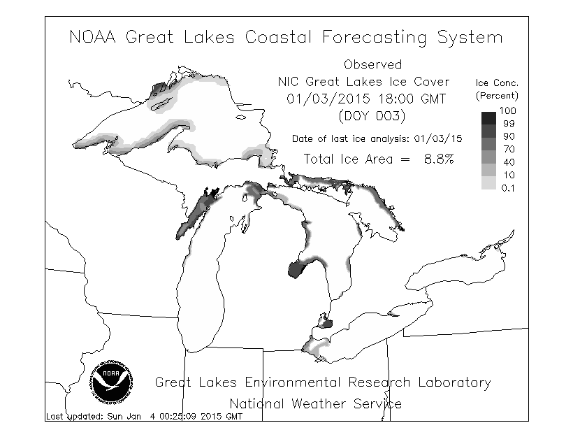 |
| Current Great Lake Ice cover |
 |
| Mean Temperature Anomoly Day 1 thru 16 |
Temperature bust...
The low level cold air was lot more stubborn than the models, any model, predicted. It's still -2C in Ottawa as of 11:30 AM. Forecasts are now saying it will only get up to 0 or +1 C. That remains to be seen. There is a tight temperature gradient. Bancroft, approx. 120 km to our west is -7C. Algonquin Part is -9. The cold is coming...
Freezing rain is still falling and will continue to do so intermittently for the next few hours...
Freezing rain is still falling and will continue to do so intermittently for the next few hours...
Saturday, January 3, 2015
About 5 cms so far
Just did the first shovel of the driveway and at least 5 cms has fallen already. Looking like another 5 to 10 before the freezing rain starts.

Sunday temperature forecast update
As indicated in yesterday's post, I thought Env. Can. forecast high temperature for tomorrow was too high (12C). Their current forecast high temperature forecast is now 2C, a whole 10C lower. Wow.
As an aside, TWN and Accuweather have a forecast of 6C as the high tomorrow
As an aside, TWN and Accuweather have a forecast of 6C as the high tomorrow
Friday, January 2, 2015
Messy storm coming up...
Not much change from yesterday's post.
A messy mix of snow/freezing rain coming up starting Saturday afternoon as snow, changing over to freezing rain Sunday morning. Currently, Env. Can. has the temperature popping to 12C. I have a hard time believing that. The NAM and WRF models have it going up to 3 or 4C. The Euro has the temperature going to 7 or 8 C. We shall see what the models say tomorrow.
All models have the dramatic drop in temperatures starting Sunday night with the coldest temps of the season coming this week.
A couple clippers will come through Wednesday and Friday (ish) bringing light snow...
Stay tuned...
Thursday, January 1, 2015
Happy New Year!
Wishing my readers the best for 2015.
This weekend's storm is looking like a ice over snow. The snow will start Saturday evening, accumulating a few inches. Temperatures will pop Sunday bringing a changeover to freezing rain and/or rain. Then there will be a rapid freeze up on Monday. So make sure you clear your snow quickly or it will be there a long time...
This weekend's storm is looking like a ice over snow. The snow will start Saturday evening, accumulating a few inches. Temperatures will pop Sunday bringing a changeover to freezing rain and/or rain. Then there will be a rapid freeze up on Monday. So make sure you clear your snow quickly or it will be there a long time...
Subscribe to:
Posts (Atom)